Route: Boston Lot/Landmark Trails
By: Jennifer Hansen
If you've always wanted to try trail running in the Boston Lot, but have been a bit deterred by its not-entirely-tongue-in-cheek "Lost - a -Lot " reputation, now is your chance to try it! You can't go off-trail because the trails that are runnable are really well packed by the groomer and fatbike tires. Many, many loops are possible, and the surface is firm and fast. It feels like a winter playground to me. I always wear microspikes so that I have no concern about slipping when the surface is icy (I wear gaiters too, to protect my ankles from the occasional spike strike).
TRAIL ETIQUETTE: I put this up front because I think this is the important thing to keep in mind when running on trails that have been groomed for/used by fat bikes. ONLY run on trails that are hard and fast, where you don't sink in. If you take a turn and find it's soft snow and you're sinking in, turn around. There are PLENTY of miles for you. If you decide to carry snowshoes and do a hybrid run/hike, you can switch out the microspikes, put them in your hydration pack, and snowshoe on the soft surfaces. That way you will not posthole and damage the trail surface for future users. If it's a warm day and you find you're sinking in right at the start, it's not a good day to run there. That said, the beauty of these trails is that once they are really hard-packed, like they are now, they are very resilient and won't soften up quickly.
Also, be aware especially when you're running downhill that if there's a biker who appears behind you, they will want to have fun and pass you - just be aware of other users.
The UVMBA website contains an interactive map so you can get to know the trail names and see if there are any trail closures. If you like to use Strava or have your phone active during your runs, you can keep track of your location. Otherwise, you can just photo the map at the kiosk or take a screenshot of the map so you can refer to it occasionally.
A couple of examples of good routes:
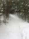
- Nature Walk to Creepy Teepee to Route 10 to Hardwoods, to Canyon to Leave it to Beaver, down Rabbit Hole to White Dot and out. Leave it to Beaver is not shown on the map, but it's a great connector route through a lovely tree-lined aisle (see photo). When going up Canyon, it's on the left just after the Bear Cave junction.
- Nature walk to Zebra, up Craft Climb via Beaver Dam, Rail it to Outback to Southside, around the lake on Westside, Northside, & Hemlock, and down Burnt Pathway and out over Beaver Dam again.
Percentage runnable: 100%
Elevation change: lots of ups and downs
Ease of Navigation: The trail junctions are marked with the names of the trails, but the trails are generally not blazed. The exception to this is around the Lake and on Burnt Mountain, where the trails are blazed blue and white.
Parking areas: The best entry points for running are the Nature walk and DHMC trailheads, because that's where the bikes go in. Entering at Sachem is less reliable since trails from there may be more often utilized by snowshoers/skiers. You can also enter by running up the access road across from Wilder Dam.
Have fun exploring!